← Back to the ranking

São Luís

MA · Northeast · State capital

Population: 1,090,229 (IBGE estimate 2026)

About São Luís

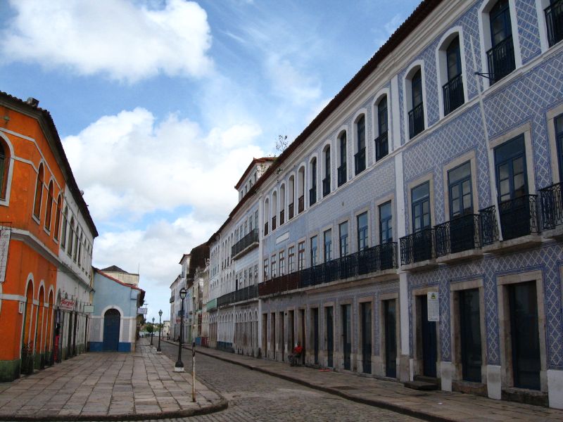
Photo of São Luís
Photo: Marcus Guimarães from Nova Friburgo, Brazil · CC BY 2.0 · Wikimedia Commons

Machine translation of the Portuguese Wikipedia article (November 2026 version).

São Luís, also known as São Luís do Maranhão, is the capital of the Brazilian state of Maranhão. It is the only Brazilian state capital founded by the French, on 8 September 1612; it was later invaded by the Dutch and finally colonized by the Portuguese. It is located on Upaon-Açu Island in the South Atlantic, between the São Marcos and São José de Ribamar bays, in the Golfão Maranhense. In 1621, when Brazil was divided into two administrative units, the State of Maranhão and the State of Brazil, São Luís was the capital of the first unit. In 1997 the city's Historic Centre was declared a World Heritage Site by UNESCO.

With an estimated population of 1,090,229 inhabitants in 2026, São Luís is the most populous municipality in Maranhão and the fourth in the Northeast Region. Its area is 583 km², of which 211 km² is urban perimeter (the 12th largest urban area in the country). The municipality is the seat of the Ilha do Maranhão Planning Region (made up of the four municipalities on Upaon-Açu Island) and of the São Luís Metropolitan Region, which consisted of 13 municipalities with a total of 1,726,262 inhabitants in 2016. According to United Nations data from 2010, São Luís's Human Development Index (HDI) is 0.768, the 3rd best among the capitals of Brazil's Northeast Region and the 4th among all 1,794 municipalities in the region.

Text: Wikipedia · CC BY-SA 4.0 · Read the full article on Wikipedia (in Portuguese)
Videos on YouTube

Each button opens YouTube in a new tab, already searching.

Attractions nearby

Well-known places within 50 km of the city center, closest first. Source: Wikidata (public domain).

Scores by topic

0 to 100, compared with Brazilian municipalities of 100,000+ residents (rent: compared among the 36 cities with rent data).

Cost of living

26

All 36 cities: 46

Asking rent (BRL/m²)

Higher rent Shown as a band among the 36 cities with rent data (thirds). See the source for exact prices.

Source: Índice FipeZAP de Locação Residencial · Reference: Sep 2026 · License: Proprietary

Healthcare

51

MA average (10 cities): 23 · All 338 cities: 34

Hospital beds per 1,000

4.02 per 1,000 residents

Source: CNES / DATASUS (TabNet) · Reference: Sep 2026 · License: Public data

Doctors per 1,000

3.07 per 1,000 residents

Source: CNES / DATASUS (TabNet) · Reference: Sep 2026 · License: Public data

Airport access

24

MA average (10 cities): 22 · All 338 cities: 60

Distance to intl. airport (km)

480.81 km

Source: ANAC – Voo Regular Ativo e Aeródromos · Reference: Sep 2025–Aug 2026 · License: Open data

International departures within 100 km

0 departures in 12 months

Source: ANAC – Voo Regular Ativo e Aeródromos · Reference: Sep 2025–Aug 2026 · License: Open data

Nearest international airport

Internacional de Belém/Val de Cans/Júlio Cezar Ribeiro (SBBE), 481 km in a straight line · 895 international departures in 12 months

Social Progress Index (overall)

65.6

score 0–100 · Source: Índice de Progresso Social Brasil · Reference: SPI Brazil 2026 (2024 data) · License: CC BY 4.0 (report)

Climate month by month

Hot Average temperature: 27.8 °C (Average temperature 25 °C (77 °F) or higher)

20 25 30 35 °C 0200400600 mm Jan: 235 mm Feb: 308 mm Mar: 453 mm Apr: 431 mm May: 312 mm Jun: 174 mm Jul: 111 mm Aug: 23 mm Sep: 3 mm Oct: 3 mm Nov: 10 mm Dec: 55 mm Jan: 31.1 °CFeb: 30.6 °CMar: 30.3 °CApr: 30.6 °CMay: 31.3 °CJun: 31.5 °CJul: 31.5 °CAug: 32 °CSep: 32.3 °COct: 32.5 °CNov: 32.5 °CDec: 32.2 °C Jan: 24.2 °CFeb: 24 °CMar: 23.8 °CApr: 23.8 °CMay: 23.9 °CJun: 23.5 °CJul: 23.4 °CAug: 23.7 °CSep: 24.4 °COct: 24.7 °CNov: 24.9 °CDec: 25 °C JanFebMarAprMayJunJulAugSepOctNovDec
Avg. high (°C) Avg. low (°C) Rain (mm)
Show monthly table
Month JanFebMarAprMayJunJulAugSepOctNovDec
Avg. high (°C) 31.130.630.330.631.331.531.532.032.332.532.532.2
Avg. low (°C) 24.224.023.823.823.923.523.423.724.424.724.925.0
Rain (mm) 23530845343131217411123331055

Weather station São Luis, 10 km away · climate normals 1991-2020 · Source: INMET Normais Climatológicas · License: Public data

Location

Nearby cities

Up to 150 km in a straight line. Scores use your weights.

  1. Paço do Lumiar MA · 16 km 40
  2. São José de Ribamar MA · 28 km 38

Cities with a similar profile

Topic scores closest to those of São Luís. Scores use your weights.

  1. Porto Velho RO · North 47
  2. Boa Vista RR · North 44
  3. Santa Maria RS · South 56
  4. Macapá AP · North 46
  5. Serra ES · Southeast 49
  6. Palmas TO · North 57

Spotted an error? Tell us · Wrong number or outdated data? Tell us which one and, if you can, the source.